Saturday, August 29, 2020

TIN BIGHA CORRIDOR– A UNIQUE INTERNATIONAL BORDER


India and Bangladesh have a common border of 4156 km covering West Bengal, Assam, Tripura, Mizoram, and Meghalaya of which the border with West Bengal is 2217 km. The border includes paddy and jute fields, water bodies, rivers, and mangrove forests of the Sunderbans.


Location

Coochbehar is the north-eastern district of West Bengal has a border with Bangladesh of 550 km of which only 250 km is under fencing. Rest is an open border where from the regular legal and illegal movement of the population takes place around the year.

There is a unique place comprising of few villages of Berubari in Mekhliganj block of Coochbehar District which is like an enclave, with the landmasses of territories of Bangladesh on both sides. Similarly, Bangladesh has two villages Dahagram and Angrapota, which are accessible from main Bangladesh through a dedicated corridor,  known as Tin Bigha.

History

Tin Bigha has a long history of its creation. After the liberation of Bangladesh in 1971, Sheikh Mujibur Rahaman, the then prime minister of Bangladesh requested Mrs. Indira Gandhi, prime minister of India, to provide access to the enclave consisting of two villages through a corridor so that the people of both the enclaves could reach the main country. A portion of land consisting of 178 meters (584 ft) by 85 meters (279 ft) which was locally measured as 3 Bighas (1 Katta is 720 sq ft and 20 Katta makes 1 Bigha) was earmarked for the dedicated corridor. The nomenclature was derived from the total area of land covering the corridor.

There was huge resistance from the local population against providing passage but ultimately the demand of the local people was ruled out. The agitation had cost few lives and so “Sahid Divas” is still observed on 26th June every year to commemorate the sacrifice of the lives of the protestors who opposed the opening of the corridor. Initially, Bangladesh wanted to take over the entire land but the Indian constitution was against such a measure. The land ultimately remained with India. Bangladesh could have access to Tin Bigha under a lease agreement.


The corridor is just like any four points crossing where two roads lead to Bangladesh and the other two to India. Initially, in 1992 the corridor was open for twelve hours - six o’clock in the morning to six o’clock in the evening for Bangladesh on an alternate hourly basis. Afterward, the gate is being kept open for normal traffic round the clock. There is a police guard controlling the traffic, both human and vehicle keeping a watch that no person crosses each other’s territory.

There is a large camp of Border Security Force which maintains the discipline of the corridor. Flag hoisting and flag-lowering functions take place every day just like Atari (Punjab) or Akhaura (Tripura) border but with limited glamour and much lower scale.

However, the border has not been earmarked for immigration on both sides and restriction has been imposed to avoid border infiltration. Fencing has been installed near the border to mark the territory of each country as no man’s land. But the partition conducted in 1947 had created confusion as many of the farmers were having their residential houses in India but their paddy or jute fields either in no man’s land or in Bangladesh.

In these areas, the peculiar situation is that some of the landmasses within India belonged to Bangladesh and vice versa. These are locally called “Chhit Mahals”. The word “Chhit” in Bengali means a piece or part and “Mahal” means palace. Otherwise, the houses or lands which fall apart from the main area of landmass are called by this nomenclature. The residents are in a pitiable condition. As they do not belong to a particular country, they are deprived of basic amenities like electricity, water, public roads, sanitation, and furthermore identity cards so as to make a free movement. However, the process has been initiated by both the governments to transfer these “Chhit Mahals” so that these populations have access to the mainstream population.

The majority of the population staying around corridors are farmers and peasants and a small section of the working population are engaged in other activities. Though there is an opportunity for paddy and jute cultivation which are done traditionally, the restriction has been imposed on jute cultivation. Jute plants at their full height restrict visibility against illegal migration to Border Security Force personnel guarding the border.

Photography of the corridor has been restricted on account of being an international border and strategic army location. 

Location        

The distance from Coochbehar Town and Jalpaiguri Town is 116 km and 54 km respectively. Since there is  irregular public transport for Tin Bigha, the tourists have to depend on owned or hired vehicle for return to their destination in district headquarters The nearest railway station is New Changrabandha (an immigration border of India and Bangladesh) a part of North East Frontier Railway which is 23 km away from the corridor. People visiting both the districts and also local people often visit the corridor to witness the flag-lowering function in the evening conducted just after sunset by the Border Security Force.


A political boundary had been drawn during the partition of Indian sub-continent in 1947, but once upon a time it was united Bengal. There was no difference in language, culture, lifestyle, food habits, heritage and mental set up of people of both the countries but the line of partition enforced the restriction of hugging each other. When people of Bangladesh and people of India met each other while crossing the corridor, they generally, greet each other from a distance to avoid vigil watch of our Army personnel.

India has a total land border of around 15200 km with Pakistan, China, Myanmar, Bangladesh, Nepal, Bhutan and Afghanistan in west, north, and east of which the longest border of 4097 km is with Bangladesh. There are porous as well as non-porous borders depending upon the diplomatic relationship with the respective countries.

Why Visit Tin Bigha

But Tin Bigha has a unique feature of a passage to villages of Bangladesh that is prevalent nowhere in the entire border of India. We are aware of the Attari (Wagha) border where army march-past has been showcased that attracts a lot of visitors especially in the tourist season and on weekends.

Since the Tin Bigha corridor is an off-beat destination, the footfall of tourists and visitors is much less. But the tourism department of the Government of West Bengal can publicize the location with proper logistics and infrastructure so as to attract sizeable tourists and visitors coming to North Bengal.

Can we not invite tourists and visitors to the state and the nation to visit the unique international corridor with more publicity and advertisement? 

Photo Courtesy Google

Video Courtesy Youtube 

Sunday, August 23, 2020

MUSICAL TOUR OF SALZBURG


When we thought of any classic movies of all times, rather more of our childhood, one of the names that came into our mind was the film “Sound of Music”. It had been a musical movie especially for children and to date it was as popular as it had been fifty years before.

The mesmerizing sceneries which were added attraction of the film drew the attention of many people like us. Everybody wanted to place themselves in that location even in the dream; the undulating landscape with lush green meadows, a big lake with a castle on the bank, snow-capped mountains, clear blue skies with spots of white cloud and children singing songs with their governess.

It had been a dream destination for anybody who had seen the film. After a gap of almost fifty years, I could fulfill the dream of being present in the shooting location with my family and friends.

The majority of its shooting took place in a small hamlet of Salzburg, with a distance of around 300 km from Vienna, capital of Austria. Salzburg had another importance of being the birthplace of Mozart, the musical maestro of all times. The place had also easy access from Munich to Germany by train and road.

Salzburg was the fourth the largest city of Austria and the capital of the State of Salzburg with a population of around 1.50 lakh. There were a number of churches, a fortress, and the dwelling house of Mozart of which we had a panoramic view. Our main attraction was to visit the locations of the shooting of “Sound of Music”. It was not only our demand but also the demand for a majority of tourists. That’s why a separate tour operating system “Sound of Music Panorama Tour” by name was prevalent. It was a half-day tour covering major locations, especially, where the popular songs were filmed.

Having disembarked from the train from Vienna, we booked the ticket for “Sound of Music Panorama Tour” paying 42 Euros for each person. We were advised to move to another end of the railway station where the vehicles for the tour were parked. As soon as we crossed the railway track through an underpass and reached the parking arena, we found a scarlet red vehicle with a seating capacity of seven persons waiting for us. Incidentally, our guide cum driver Ms. Michelle welcomed us and we were told to wait for other passengers and the car would leave exactly at 09.30 hours in the morning.

When we got into the car, we found one of our members missing. We frantically started searching for him within the station premises and in the surroundings. Our objective was to search mainly in the mobile phone repairing outlets as he was complaining about some problems with his mobile phone. We started shouting even breaking the decency, to reach him but failed. Our guide was also anxious as she was tied to the time schedule so we had to move without him.  

It was totally a guided tour and as soon as we started, the famous song “Doe a deer, a female deer” started playing in the recorder of the vehicle. Having crossed the downtown area and keeping the birthplace of Mozart on our right, we proceeded towards the hamlet where the lake and Leopoldskron Castle was located. The castle was the residential building of Captain Baron and his children. We were brought on the opposite side of the lake and could see the castle along with a marble statue in the garden. Since the entry in the castle was restricted, we had to satisfy ourselves by watching it from a distance. The lake, where the boat carrying children along with Maria, the governess overturned, flocks of sparkling white geese were swimming in the water. Still, the castle, lake, garden, flocks of geese were there but could only recollect Maria and the children.

Then, we moved towards the Werfen Picnic Meadow where the famous song “Do Re Me” was shot with the children and Maria sitting on lush green meadows with velvet-like grass, snowcapped mountains, and chirping of birds. We walked through the meadow and imagined ourselves to be one of those children of the Captain learning music from Maria….”Do Re Me”. We spent around half an hour in the meadows enjoying the cool breeze and mesmerizing beauty of the Austrian Alps in the backdrop, thinking if our childhood would have been spent in such a heavenly place. Call from our guide reminded us of time restriction and we had to move to the next location.

Though we were enjoying the locations, we kept on thinking about our missing member in the back of our minds. His wife was also irritated and anxious about the negligence of her husband. But we were totally helpless and had to wait for our destiny.

Those who could remember the famous heartthrob song “You are sixteen, going on seventeen”, could not forget the love of teenagers, their dance, the rain and the enclosure of the park. The shooting took place in Heilbrun Castle and the Glass Pavilion. It was a recapitulation of our teenage when we moved into the park of the castle and the pavilion and our guide was playing the song. It was really a terrible feeling. The scenery of dancing couple in rain, the song, and the entire environment was just flowing in our mind like a flashback.

Our next destination was the famous Mondsee Wedding Church where Captain and Maria got married in the last session of the film. The church was located in the heart of downtown with the huge open arena in front. We had ample time to visit inside the church but our movement was limited as marriage was in progress. We loitered outside the church enjoying the sunshine and cool breeze.


Since time was limited, we had to move to our next and the last destination, Mirabell Garden where the children used to come to play with their governess Maria. The scenes of children climbing up and down the staircase, swinging around the fountain, running through the flower garden, and encircling the statues were shot here. We saw the children of the present world enjoying the beauty of Mirabell Garden in their colorful clothes, with the same jovial mood and satisfaction, and tried to recollect what happened about half a century ago. Those children might have become adults and some of them might have grandchildren of that age. We could visualize those days and compare them with the children of present cherishing the memories.

Since Mirabell Garden was very near to Salzburg Railway Station, we preferred to walk back to our destination with the anxiety of searching our missing member.

Having reached the station, we found our missing member enjoying a large cup of cappuccino with a new mobile phone in his hand. It was learnt that he tried to get the mobile phone repaired but ultimately failed to do so. As an ultimate choice, he purchased a new mobile phone. After purchase when he came down from the first floor of the shopping mall, he learnt from the booking counter, that the vehicles for panorama tour had already left. As a result, he had to pay the penalty for missing such a beautiful tour at the cost of a mobile phone.

We returned to the platform of the station, with full satisfaction for visiting such a wonderful location in the lap of the Austrian Alps and carried memories of the great film. Soon we boarded for our return journey to Vienna with the desire to come back to the heavenly place again.

  Film Courtesy YouTube

Thursday, August 20, 2020

INTO THE HEART OF KUNCHENDZONGA-TREKKING TO GOECHA LA

Trekking had not been my passion anytime but my first trek to Sandakphu and Falut inclined me to go a step ahead and I joined our office trekking group to Dzongri and Goecha La despite the absence of normal fitness. There was strong resistance from my family as it was a tough trekking route and my experience of trekking was not enough to undertake such type of trekking.

I was determined to undertake the trekking programme with zeal and the enthusiasm with the condition that I would return from the point wherefrom I would not be able to cope up with the speed of the team.

Finally, on the D-day, the entire team started from Sealdah Railway Station of Kolkata with our trekking baggage and reached New Jalpaiguri Railway Station the next morning. After hiring a vehicle our team consisting of five members started from the railway station to Yuksom in West Sikkim covering a distance of 145 km. We had two breaks on the road for breakfast and lunch and finally, we reached our destination in the afternoon.

Since we had the plan to start for trekking on the next day itself, we checked in a guest house, not very clean but somehow habitable, and then proceeded to a tour operator for obtaining a permit, hiring of porter-cum-guide, and arrangement for other consumables. Since the trekking was for around nine to ten days, an adequate quantity of rice, lentil, tea, noodles, potato, egg, onion along with spices, kerosene, matchstick boxes, candles, etc was purchased as per instruction of porter-cum-guides. The utensils, stoves, and other logistics were provided by the trekking agency on a hiring basis. It was also decided that two porter-cum-guides would accompany us who would carry our luggage also.

It was advised to keep one day in the base location for acclimatization but my other teammates were matured and experienced to undertake the trekking on next day itself though I was the odd man out. As a result, the preparation time was very less and we had to be doubly sure that essential items got missed out as nothing would be available on the way and no other trekking team would spare any of these necessary items even if they were willing to do so.


First-Day

At around 7.30 hrs in the morning, after breakfast, we started our trek from Yuksom. After completion of the formalities of the forest department, checking our belongings by forest guards we entered the main trekking path. Our target was to reach Bakhim covering 12 km located at the height of 2750 meters. The trek was with gradual elevation through the dense forest of pine and oak and at times pebbled path. Since I was considered most inexperienced, the team took me as a benchmark. We crossed the Prek-Chu river, which was more of a rivulet with a strong current. On the way, we had our lunch in the form of bread, butter, and tea as the cooking of food would consume much of the journey time. But it did not seem to be very tough and ultimately at around 15.30 hrs, we reached the trekking hut at Bakhim. By evening, it was pretty cold, though we had sleeping bags and adequate warm clothes. The porter-cum-guides prepared tea and then Khichdi (a cooked mixture of rice and lentil) and by 17.30 hrs our dinner was ready. Being dog tired and to avoid consumption of candles, we took our dinner and placed ourselves in the sleeping bag and soon moved into another world.

Second-Day

We got up from sleep at around 03.30 hrs based on a call from porter-cum-guides. It was pitch dark outside with stars glittering in the clear sky. But instead of enjoying nature, we had to make ourselves ready for the next journey to Tshoka covering a distance of around 05 km. The complexion of the forest changed with an abundance of rhododendron and magnolia trees and snow-capped mountains could be seen at a considerable distance. The meandering way led us to a point where we could see Mt Pandim and few other ranges as identified by our porter-cum-guides. The path was becoming difficult because of gradual to steep elevation and all of us started panting and sweating despite the cold wind blowing across the forest. Having taken lunch with Maggi on the way, we reached Tshoka village at an elevation of 3050 meters. Soon we reached the trekkers' hut of Tshoka. The hut was not in good condition and our porter-cum-guides had to toil hard to make it habitable. Few other trekking teams also occupied a portion and we had to confine ourselves in one corner. The next routine was as usual with dinner at around 18.30 hrs and then entering into the sleeping bag. Though there was enough scope to enjoy nature at night our body did not permit us to keep ourselves awake.


Third-Day

We were waken up by our porter-cum-guides with the warning that our day’s trek would be tougher and we should prepare ourselves accordingly. We were to move to 4020 meters covering a distance of around 10 km. Having breakfast and tea, we started our trek along the jungle path with new zeal. There was an increase in the degree of elevation and after an hour or so, we could realize that today’s trek was not a cakewalk. The change in types of trees, chirping of birds was visible. Despite panting and sweating, vegetation on the way helped us to regain energy and there was no problem in attaining oxygen level. Around noon, we reached Phedang and the porter-cum-guides prepared Maggi. We found that Maggi had become part and parcel of our breakfast, lunch, and dinner. Our next lap of the journey started soon after lunch and by afternoon, we could see the trekkers hut at a distance. The visibility gave a boost to our trek and we reached trekkers hut at Dzongri. We congratulated ourselves to reach the first leg successfully. The next routine as usual comprised of tea followed by dinner and sleep.

Fourth-Day

Our target was get up very early and moves to Dzongri Top to have a view of Mt. Kunchendzonga, Mt. Pandim, and other ranges under the rays of the rising sun. It was really a marvelous sight as the weather did not betray us and we could have a clear view of all the ranges to our full satisfaction. Having come down from the Dzongri Top, we started to move for Thansing via Kokchurang (10 km). On the way, we had a glimpse of Kabru North, Kabru South, Kabru Dome, Simbho, Jupno, and many other ranges as identified by our porter-cum-guides. The vegetation had been thin and the colour of trees changed from green to yellow. Most of the trees were of canopy type to withstand heavy snowfall. We followed the trails of our earlier trekkers. There was no trace of a human being but the residues in the form of plastic packets and water bottles depicted the irresponsible attitudes of some trekkers. We reached Thansing a little late as the removal of leeches from socks and shoes took away much of our time. We took dry lunch in the form of cakes, biscuits, and nuts at Kokchurang along with tea. Thansing trekkers hut was again in a dilapidated condition but somehow we managed to station ourselves in one corner, sharing the hut with two Irish couples. After dark, the gusty wind started rolling within the hut in the absence of windows, but the fatigue did not allow us to keep awake.

Fifth-Day

The initial routine was as usual. We started our trek with the target to reach Samiti Lake which would be around 10 km at an altitude of 4300 meters. It was again warned by our porter-cum-guides to reach as early as possible to have adequate rest because of altitude and next morning trek to Goecha La which would start at 02.30 hrs. The meandering way with gradual and undulating slopes took us to our destination. We met many rivulets, springs, and waterfalls which enhanced the beauty of nature and rejuvenated us sprinkling cold water on our face and body. We had lunch at Lamuney, again with dry items along with tea, and increased our speed to reach early and enjoy Samiti Lake from all dimensions. At around 15.30 hrs, we had a glimpse of Samiti Lake from a distance. 
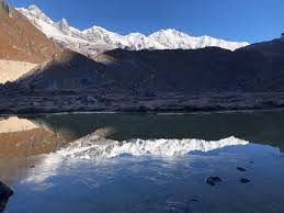
Having gained fresh energy, soon we reached the trekker's hut. Having enjoyed a cup of tea, we started encircling the lake to have a 360-degree view. It was a small lake strategically located at such a height with clear water and shadow of the mountains. Since our next day programme was to start very early, we took dinner in broad daylight and inserted ourselves in the sleeping bags.


Sixth-Day

It was absolutely pitch dark. Being loaded with warm clothes to combat the bitter cold, we started our journey with nap sack carrying water and dry fruits. We had a stick and torch to manage our trek smoothy. Narrow and slippery path, loose snow, and dark reduced our speed to a considerable extent. We had to count every step as we were not able to assess the depth of the gorge on one side. It was a sigh of relief when the first rays of the sun could be seen. The elevation was quite steep and each person was following others behind the porter-cum-guides. As we proceeded, Mt Kunchendzonga, with its robust feature stood before us with a golden crown on its head. Really, it was the ultimate beauty for which we had put so much of labour and hardship. We stood at Goche La Top for around thirty minutes and enjoyed the full sunrise. The other ranges were visible but they seemed to be trivial before the great mountain. We prayed to God who allowed us to enjoy the splendor of eternity. Our porter-cum-guide warned us to return to avoid any probable accident on account of melting snow. We returned to Samiti Lake trekkers' hut and took a rest for the whole day cherishing the memories of attaining the coveted goal.


Seventh-Day

We started our return journey from Samiti Lake intending to reach down as far as possible. The return trek was slightly easier on account of the downward journey and by afternoon we reached Kokurchang trekkers hut having crossed Thansing and Lamuney. We had dinner and good sleep as the temperature was slightly higher than Samiti Lake. We had to share the hut with two groups from India who were on the way to Goeche La.

Eighth-Day

After the usual morning routine, we started our trek with no perfect plan but intending to reach at least Bakhim. One of our members suddenly faced muscle cramps and we had to reduce our speed and by afternoon we reached Tshoka trekkers hut. A sign of inhabitation could be seen in Tshoka and some of our group members enjoyed Tomba, a local drink made of millet, in a wooden container, and using a wooden straw. We had a taste of egg after a few days as it was available with a local vendor.

Ninth-Day

Now, trekking had become a cakewalk and our speed almost doubled on our downward journey. Finally, reached Yuksom covering a distance of 10 km. We bade farewell to both of our porter-cum-guides and thanked them for systematically managing the entire programme with perfect timing sense and proper guidance. We enjoyed the night with a sizzler along with a sumptuous dinner to commemorate our successful trek.

The greatest lesson of the trek was that if one was determined to achieve a target, one could achieve. Practically speaking, I myself was not very sure to reach the goal and I was ready to quit in case of any difficulty, but the teamwork helped me to overcome the hurdles and ultimately I succeeded. Further, we also realized that nature had been bountiful and at the same time nature was niggardly. We could extract the essence of bountiful nature through the tough test.

Photo Courtesy Google

Important Information on Dzongri – Goecha La Trek

Ø Starting & Ending Point – Yuksom to Goeche La & Back

Ø Reaching Point – NJP to Yuksom via Melli, Jorthang

Ø Altitude (Highest) – 16200 ft

Ø Duration of Trek – 9 days Yuksom to Yuksom (up & down)

Ø Distance to be covered – App 90 km

Ø Temperature – Morning & Night (-5 degree C to 10 degrees C)

                                  Day (10 degree C to 25 degrees C)

Ø Season for Trek – April, May, October & November

Ø Accommodation – Trekkers Hut, Homestay

Ø Trekking Difficulty – Initially smooth but difficult with changing terrains


Sunday, August 16, 2020

CROSSING THE DEEP SEA – ANDAMAN BY SHIP


It was exactly eight o’clock in the evening. We could hear the siren of the ship and rushed towards the deck. Since we were in the first-class cabin and the same was just one floor below the deck, we could reach the open deck within minutes. The ship tilted towards left and gradually moved away from the dock. The crew, sareng, and other staff were on different position of the deck and received instructions through loudspeakers from the ship as also from the dock in their code language which we could not understand.

Yes. Finally, we were moving to Port Blair from Kolkata crossing 1125 nautical miles through the Bay of Bengal. We boarded the ship, MV Harshavardhan with our luggage at around three o’clock after lunch after checking of tickets, entry pass and various other formalities as Netaji Subhas Dock of Kolkata Port Trust is a restricted area.

Availability of ticket had been another difficult task for us. The tickets were issued after the announcement of the date of journey from Kolkata office of Shipping Corporation of India. Since the number of seats was limited and islanders had first preference followed by government officials, so few residual tickets were allotted for the general public. Having stood in the queue from almost midnight, ultimately we could manage four tickets in a first-class cabin. Other than first-class cabins, there were deluxe cabins for two persons, second class cabins for six persons and bunks in two levels.

The ship was of moderate size with a capacity of more than a thousand passengers, the majority of them were either resident of the island or labourers going from the mainland. There were a swimming pool, table tennis and billiard room, library, restaurant, television room, stationery shop attached to the restaurant and a large dining room open from three sides to have 180 degree view of the sea.

After the ship plunged into the river Ganga, it took speed and started moving steadily. Since it was a night with poor visibility, we took dinner, brought from home, and went to sleep so as to enjoy the beauty of the sea the next morning.

Early morning, we got up and found the ship was anchored in Ganga itself and we were really disheartened not to be able to enjoy the voyage in real sense. It was learnt that the ship needed two high tides to reach the delta of Sunderbans was known as “Sandhead”.The first high tide took us to around sixty nautical miles and the ship could not move further because of silt deposition and had to wait for next high tide which would help to carry the ship to the sea.

All the passengers were advised to reach the deck through the public address system and the captain and other crew members taught to tackle the situation in case the ship was in distress. We were shown the locations of lifeboats, the order of preference of boarding lifeboats, wearing of life jackets and refuge area in case of fire in the ship. We were advised to purchase voyage food coupons from the restaurant which would be valid for bed tea, breakfast, lunch, evening tea and dinner for the entire journey.

At around ten o’clock the ship started with sirene and we could see the ship was following a small boat “Rupsa” by name. The boat worked as a guide as the ship might get stuck up due to silt deposition in both sides of Ganga. We gradually crossed parts of Sundarban, Sagar Island and could see the temple of Kapilmuni or popularly known as Ganga Sagar in the distant horizon.

Suddenly, another boat of similar size “Chandrima” appeared from nowhere and parked beside our huge ship. A crew from that boat came up to the ship through rope ladder and a crew from our ship disembarked to that boat. Both the boat left for return journey upstream. We came to know that the crew who operated from Kolkata to Sandhead was replaced by a crew who would be in charge of an entire sea voyage.

Gradually, the muddy water changed to the green water of Bay of Bengal and flocks of seagulls were moving around the ship, might be for the search of food.

The timings of breakfast, lunch and dinner were being announced by the public address system and the passengers had to enter the dining hall in batches. Though the ambiance of the dining hall was good with an open view, the quality of the food served was not up to the mark as there was no variation in the menu. Tea was being served at cabins and bunks. We started moving in the ship searching for any unknown locations which we missed earlier. With the help of one crew, we had a chance to visit the main navigation room wherefrom the ship was operated by the captain. We could not enter some prohibited area for passengers because of statutory restrictions.

We enjoyed the cool breeze and changing the colour of clouds along with the movement of seagulls. We again saw a change of colour of the sea from green to blue and ascertained the change of colour was due to the change of depth of the sea. When the ship was moving through the changing colour of the sea, we could see a distinct border of green and blue. In the evening, we were inclined to enjoy the beauty of nocturnal nature from the upper deck than keeping ourselves confined to cabin.

Next morning, when we landed in the deck, we found the colour of the sea had turned to be totally black and the depth of sea had increased to a considerable extent. We could realise the reason why people used to call Andamans as “Kala Paani”. Lots of flying fishes moved either in the air or plunged into the sea. If the deck had been little low, some of them would have landed on the deck itself.  

At around eleven o’clock in the morning, while standing on the deck, we found that garbage and food waste were being thrown into the sea through a huge pipe. Few crew members were also relaxing on the deck with whom we interacted to learn their experiences. The normal movement of the ship cutting through the waves was called “Pitching” and that did not cause a health problem. But the rough sea waves tilted the ship from both sides which were called “Rolling” that created giddiness and nausea to the passengers which were popularly known as “Sea Sickness”.  Majority of them opined that the toughest period of the voyage was monsoon which remained from April to September, sometimes extended till October. Moving on the decks became impossible because of huge waves along with the gusty wind. There had been few deaths where the crew on the deck could not survive the blow of waves and wind. The others had to be dumb witnesses to those tragic incidents and most of the bodies could not be recovered. One of the crew suddenly drew our attention to the sea where we could see tail fin of a shark just above the water level. Since the colour of the shark and the sea were identical, we could not identify the shark and within the twinkling of an eye, the shark vanished into the deep sea.

In the evening, the sky was pitch dark and we were guided by stars and with no sign of moonlight. Suddenly, signs of light on our left side in the horizon were visible through the naked eye. We came to know that it was Coco Island in Bay of Bengal presently occupied by Myanmar.

Next morning, we again saw an island in the distance which was called Barren Island, where the only active volcano of India is located. At around lunchtime, we had the first view of North Andaman, with Diglipur as headquarters followed by Mayabunder of Middle Andaman. It was a pleasant sight and the passengers were delighted to have the view of the land after two days. But the ship did not touch any of the islands and was moving through mid-sea keeping the islands at a distance.

The colour of the sea again changed to blue and by evening, it was announced that the ship was much ahead of schedule on account of a favourable wind and likely to reach Haddo, the port of Port Blair by around ten o’clock at night. We were slightly anxious, as our disembarking schedule was around four o’clock in the morning and the vehicle was advised to reach Haddo accordingly.

After dinner, around eleven o’clock, we could find the ship harboured at Haddo and after completion of formalities; we had to disembark from the ship. As we were thinking about how to reach our hotel at night as a number of vehicles were less and mostly all booked, one person introduced us as a hotel driver and we really had a sigh of relief when we found that hotel had taken the responsibility of sending the vehicle, based on the changed schedule of ship.

It was really a lifetime experience for us travelling through the midst of the sea and enjoying the beauty of changing nature and changing the colour of the sea. The ship, though of considerable big size seemed to be a minuscule creature in lap of the huge water mass.

The majority of the population of India could not afford to board luxury cruise operating in western countries because of accessibility and cost. It would be a unique experience for them to enjoy the sea onboard.

Ship Fare for non-Islanders (per person) as per SCI website

ü Deluxe Cabin Rs.11295/-

ü Semi Deluxe Cabin Rs.10290/-

ü First Class Cabin Rs.9365/-

ü Second Class Cabin Rs.7445/-

ü Bunk Class Rs.2905/-


Photo courtesy Google

Backlink

https://www.youtube.com/watch?v=ttHBg25J-y4         


ZIRO - A DAY SPENT IN APATANI VILLAGE

It was solo traveling in a real sense within the lockdown period. I had to take extra care carrying all my necessary utilities along with sp...